
High-reliability Onshore LiDAR Wind Measurement Solutions and Project Case Sharing
Highlights
1. Core advantages: High-reliability multi-redundant design; end-to-end backup with multi-protection for key components; dual-path parallel data ensuring stable operation under extreme conditions.
2. Customized solutions: Terrain-adaptive, long-term stable operation, multi-height wind data acquisition.
3. Extreme environment adaptability: 99.96% LiDAR availability, 100% weather station availability in an onshore project with typhoons and prolonged rains.
There are significant differences between onshore and offshore wind measurement in terms of environmental conditions, device requirements, and data collection difficulty. Offshore wind measurement faces complex marine environments such as high salt spray, strong corrosion, and large waves, which require extremely high device protection levels and stability. Onshore wind measurement, on the other hand, is affected by factors such as topography and vegetation coverage, and it is necessary to select an appropriate wind measurement scheme according to different terrains.
Onshore Wind Resource Measurement Solution
Blue Aspirations has a complete wind resource measurement system with efficient and stable data collection and transmission capabilities. It also has an experienced team of technical experts that can provide end-to-end wind resource assessment services from scheme design to data analysis, empowering customers to make scientific decisions and optimize wind power development strategies.
For onshore wind resource assessment, Blue Aspirations designs reliable LiDAR-based wind measurement solutions tailored to customer needs. These solutions are suitable for various complex terrains and off-grid environments, support long-term stable and autonomous operation, and accurately obtain key data such as wind speed and wind direction at different heights. The standardized service process includes:
1. Site survey: Conduct a comprehensive on-site investigation of the project deployment location, measure key data such as topography and meteorological conditions, and provide a scientific basis for scheme design.
2. Customized solution and selection: Tailor wind measurement solutions according to project characteristics and customer needs, and select suitable device models.
3. Device production, integration and debugging: Strictly follow standards for device production and integration, and complete system debugging to ensure stable device performance.
4. Rapid deployment: Complete on-site device deployment within 1-2 days to ensure project launch on time.
5. Data transmission: Transmit collected data back to the server daily via mobile network or satellite to ensure data timeliness and availability.
6. Data analysis and report delivery: Professional teams conduct in-depth analysis of collected data, form detailed data analysis reports and deliver them to customers in a timely manner.
In addition, Blue Aspirations also offers LiDAR-free integrated hardware systems (including power supply, control, and communication modules) and remote monitoring systems. With a complete quality control system and high comprehensive cost-effectiveness, we provide customers with diversified choices.
Case Study of an Onshore Wind Measurement Project
The following is an in-depth analysis of an onshore wind measurement project for which Blue Aspirations has completed one year of measurement work. This project is deployed in a typical island terrain area.
Site Survey
Before the implementation of the project, the Blue Aspirations technical team first conducted a comprehensive site survey of the deployment location. By measuring key data such as topography, sunshine duration, and solar radiation intensity on site, combined with in-depth data analysis of historical meteorological records, they accurately estimated the theoretical power generation capacity of the solar power system. At the same time, taking into account the power demand, equipment power consumption, and power supply reliability requirements under extreme weather conditions, they performed detailed calculations of the overall power system load. Based on these scientific analysis results, a customized configuration plan was determined for the project.
Customized solution and selection
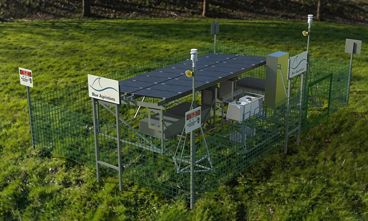
The technical team, taking into account the client's wind power development planning and assessment needs, and relying on core data obtained from the site survey, tailored wind measurement solution for the project. In response to the complex terrain and variable meteorological conditions of the island, they precisely matched the appropriate LiDAR model, optimized deployment locations and detection parameters, ensuring efficient capture of wind resource data at different altitudes. Meanwhile, considering installation methods, dimensional specifications, and measurement accuracy requirements, they selected a suitable weather station model. The project is equipped with two sets of LiDAR systems and weather stations, with a redundant design to ensure stable system operation. To address off-grid environments, the technical team meticulously designed a multi-source redundant power supply system consisting of "solar panels + diesel generator + battery bank," ensuring year-round stable operation of the wind measurement equipment. Based on the project budget, the diesel generator serves as the backup power source in this solution. For other customized configurations, direct methanol fuel cells (DMFC) supporting automated control are also available to customers as an alternative backup power solution. To prevent interference from unauthorized personnel, physical fences and warning signs were installed around the deployment locations.
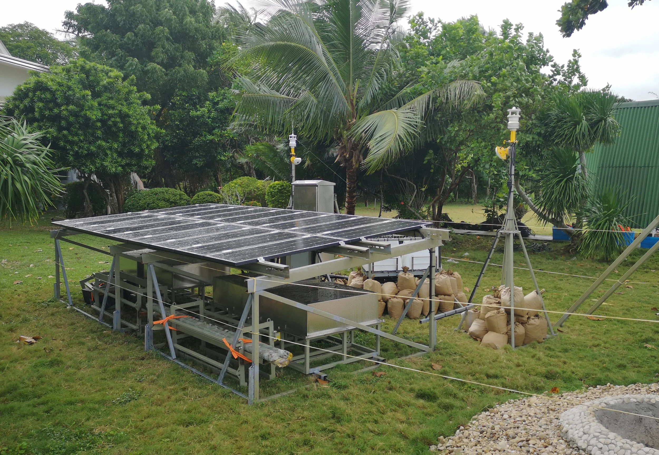
Installation and Commissioning
During project implementation, the Blue Aspirations technical team carried out equipment installation and commissioning in strict accordance with standardized procedures. Based on the site survey results, the optimal equipment installation locations were first determined; then equipment assembly and installation were performed to ensure that the levelness and verticality met the requirements; finally, system commissioning and trial operation were completed to ensure the normal operation of the equipment.
Device Configuration
LiDAR wind measurement technology, as an advanced wind measurement method, has incomparable advantages over traditional wind measurement towers. It can realize remote non-contact measurement, is not restricted by terrain, and can quickly obtain wind resource data at different heights. Meanwhile, LiDAR wind measurement device is small in size and light in weight, easy to transport and install, and can be deployed in a short time, greatly improving wind measurement efficiency.
The LiDAR used in this project is based on the principle of pulsed laser coherent Doppler, with advanced technical performance, and can accurately measure data products such as wind speed (accuracy up to 0.1m/s, range 0~75m/s) and wind direction (accuracy up to 1°, range 0~360°). The radar's working height covers a vertical range of 30-300 meters, which can meet the wind resource measurement needs of different heights. In addition to two LiDARs, this project is also equipped with two miniature weather stations for monitoring ground wind speed, wind direction, atmospheric pressure, temperature, humidity and so on.
The entire measurement system is equipped with an independent self-powered system. The power supply system for this project consists of four solar charging panels and, subject to budget considerations, is augmented with a diesel generator serving as the standby power source. The energy storage part consists of two maintenance-free lead-acid batteries. The power supply system adopts a redundant design concept. If one or more sets fail, the system can automatically cut off the faulty power supply to ensure normal power supply.
System Availability of Measurement Devices
System availability is used to measure the data collection capability of device, i.e., whether hardware and software can continuously and stably obtain original signals. The higher the system availability, the more stable the device operation, and the less data loss caused by obstruction, signal attenuation, power outage and other reasons. During the measurement period from December 2024 to December 2025, the system availability of the LiDAR wind measurement devices in this project reached 99.96%, and the system availability of the weather stations reached 100.00%, which fully reflects the stability of the devices and the reliability of data collection.
Valid Data Availability of Wind Measurement Systems
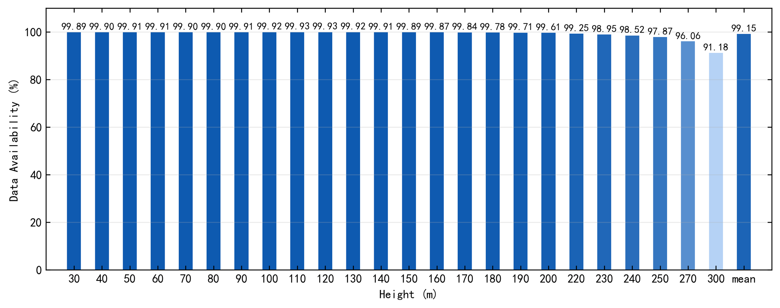
Valid data availability reflects the ability to produce valid data, which means eliminating physically unreasonable or poor-quality data (invalid records, such as low signal-to-noise ratio, abnormal correlation, or values beyond reasonable ranges) from the collected data. It depends on the strictness of algorithm quality control and the detection environment (aerosol concentration, atmospheric turbulence, rain and fog, etc.). The data measured by the LiDAR in this project covers a total of 24 measurement heights from 30m to 300m. During the measurement period from December 2024 to December 2025, the data availability of the 19 heights at and below 220m is all above 99%. The data availability of the 5 heights above 220m ranged from 91.18% to 98.95%. Here, with the height increasing, the valid data availability decreases correspondingly, which is consistent with the characteristics and measurement principle of the LiDAR. The average data availability of all heights is 99.15%, and the data quality is at an excellent level.
Overall valid data availability of LiDAR
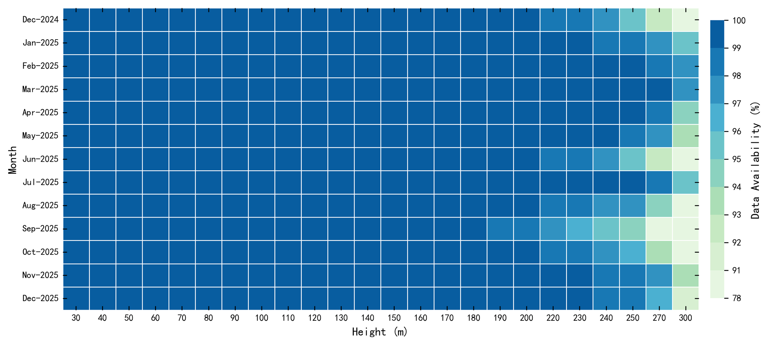
During the measurement period from December 2024 to December 2025, the wind measurement system demonstrated exceptional stability despite extreme climatic challenges. The project site experienced a prolonged rainy season from June to November 2025, and was further tested by the super typhoon "Ragasa" in September of the same year. Despite these dual challenges, the monthly valid data availability at heights from 30m to 270m remained consistently above 90%. Notably, the data availability at heights from 30m to 200m stabilized above 98.5% throughout the year, exhibiting extremely high stability and establishing itself as a reliable data collection interval for wind resource measurement. Although the valid data availability at heights above 200m showed a periodic downward trend, particularly noticeable in December, June, and September, it remained at a relatively high level overall. This fully validates the system's strong adaptability and data collection reliability in harsh environments.
Monthly Valid Data Availability of LiDAR
Valid Data Availability of Weather Stations
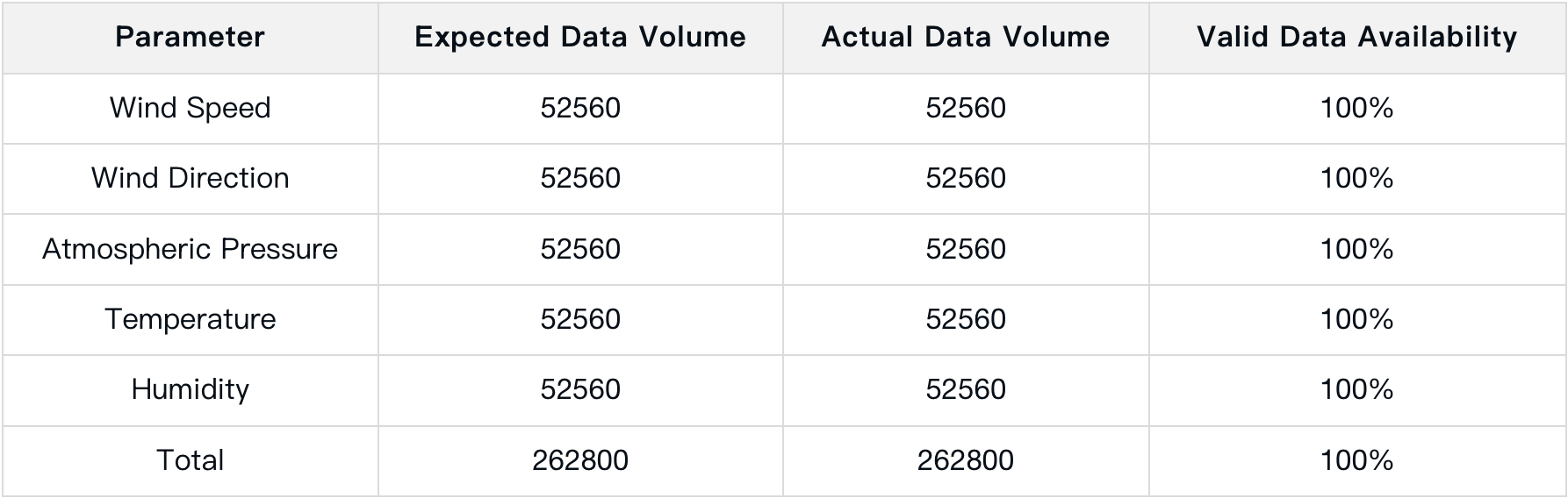
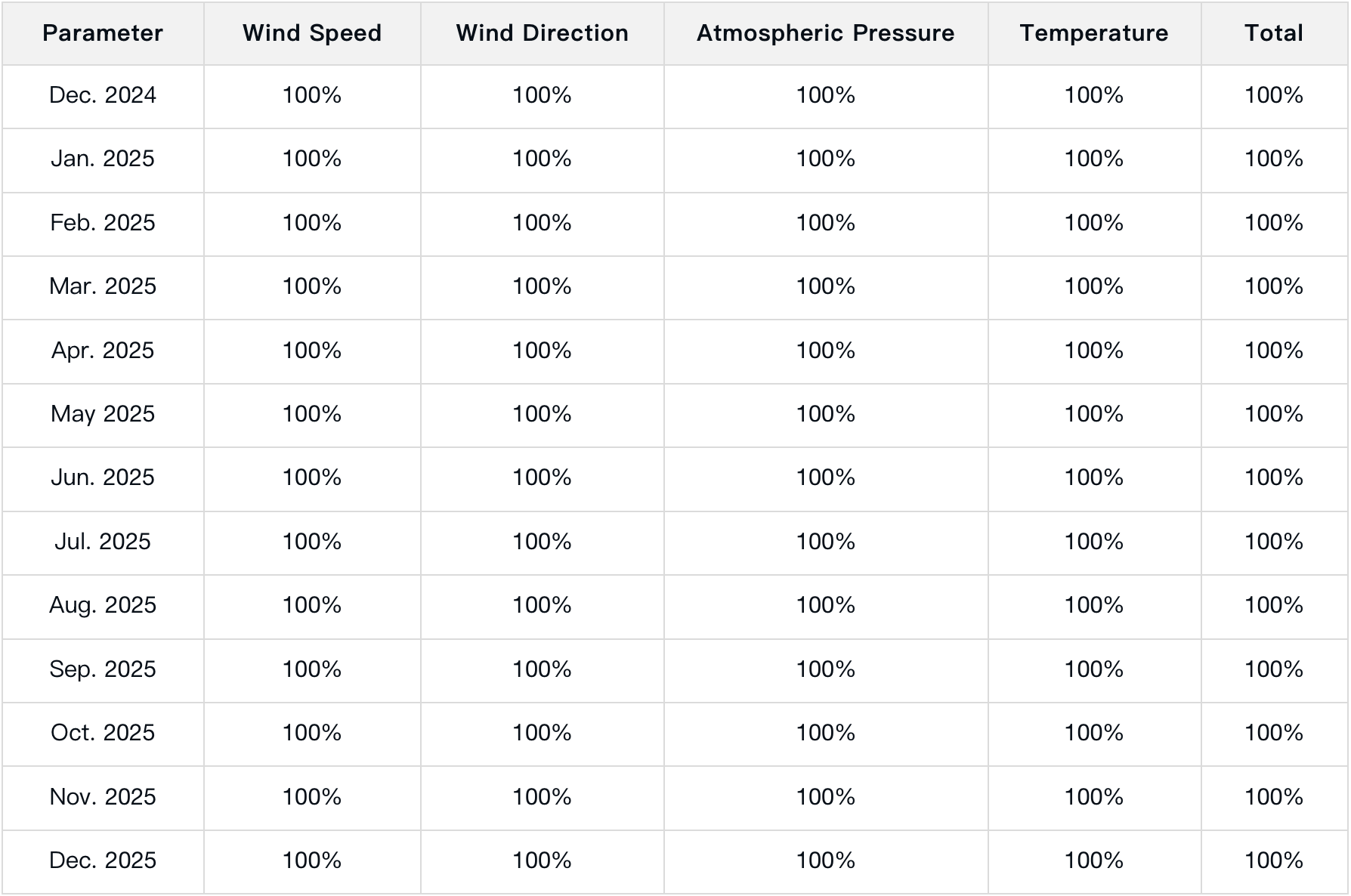
The data collected by the weather station covers five core indicators: wind speed, wind direction, atmospheric pressure, temperature, and humidity. During the measurement period from December 2024 to December 2025, despite the extreme climatic challenges of the aforementioned prolonged rainy season and super typhoon, the valid data availability of the five indicators all reached 100%. The monthly valid data availability also remained 100%, free from missing or invalid data, demonstrating exceptionally high data quality.
Overall valid data availability of weather stations
Monthly valid data availability of weather stations
Through a customized LiDAR wind measurement solution, this project has been successfully applied to wind resource assessment in complex terrain, achieving end-to-end services from data collection to decision support. During the project implementation, standardized service procedures were strictly followed to ensure stable device operation and accurate data collection. Finally, excellent results were achieved with a LiDAR system availability of 99.96% and a weather station system availability of 100%, fully validating the technical expertise and service capabilities of Blue Aspirations in the field of wind resource measurement.
In the future, Blue Aspirations will continue to focus on the innovation and optimization of wind resource measurement technologies, pursuing technological breakthroughs for extreme scenarios such as complex terrain to further enhance the stability and accuracy of data collection. At the same time, the company will consistently improve its end-to-end services to provide customers with more professional and efficient wind resource measurement