
A 7-year Milestone | First and Only in Asia: BA-FLS-NX5 Achieved OWA Stage 3
On 8 September 2026, Blue Aspirations' BA-FLS-NX5 Floating LiDAR System was formally granted Stage 3 commercial maturity status under the Carbon Trust Offshore Wind Accelerator (OWA) Roadmap for the Commercial Acceptance of Floating LiDAR Technology v3.0 (June 2025) — marking the company's entry into the international commercial maturity stage for floating wind measurement technology.
After becoming the first Chinese manufacturer to achieve Stage 2 in 2023, Blue Aspirations is now the only floating LiDAR supplier in Asia to have reached Stage 3 (based on publicly available information as of September 2026).
1. The Rigour of Stage 3: Three Thresholds in Combination — Failing Any One Invalidates the Whole
The Carbon Trust Offshore Wind Accelerator roadmap(v3.0) for the commercial acceptance of floating LiDAR technology is the floating LiDAR technology-maturity framework widely adopted across the global offshore wind industry. Within that framework, Stage 3 is the “Commercial” maturity stage for wind speed and wind direction measurement; it requires a system to be demonstrated in real offshore environments over long periods, across multiple sites, multiple units, and a range of sea states, rather than relying solely on laboratory or short-term testing.
Stage 3 does not request that a system “has been measured once”, but rather that three categories of evidence hold simultaneously.
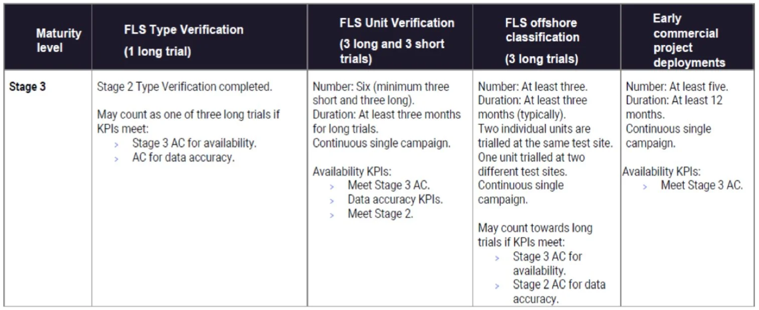
Quote from OWA Roadmap for the commercial acceptance of floating LiDAR technology v3.0
More stringent still: every trial and every deployment must simultaneously satisfy the same set of KPI acceptance criteria — a single miss on any one of them invalidates the whole.
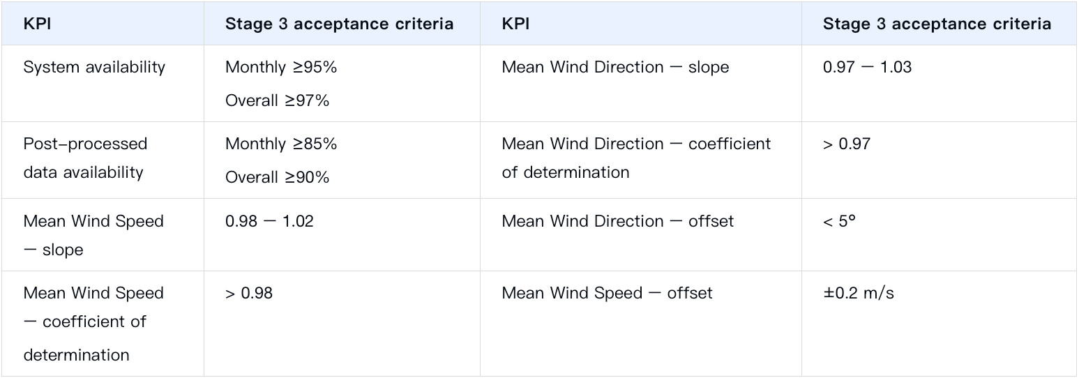
Quote from OWA Roadmap for the commercial acceptance of floating LiDAR technology v3.0
The difficulty of Stage 3 lies not only in the number of trials but also in the systematic, comprehensive verification of the system's performance under different environmental conditions.
One easily overlooked requirement, which bears directly on the final uncertainty assessment, is the systematic evaluation of the system's sensitivity to the relevant environmental and operational variables, including: wind shear exponent, turbulence intensity, precipitation, RSD availability, wind direction, air temperature, air density, temperature lapse rate, upflow, and wind veer gradient. Where any environmental variable shows significant sensitivity, it must be included in the calculation of classification uncertainty and cannot be disregarded. This means that Stage 3 cannot be passed by completing a few trials and obtaining a set of favourable results: it requires building a complete evidence chain covering system performance, environmental adaptability and uncertainty assessment.
More importantly, this evidence chain must also undergo systematic assessment by an independent third party rather than self-certification by the manufacturer. The Stage 3 verification of the BA-FLS-NX5 Floating LiDAR System was assessed by an internationally recognised third party, which verified each item of evidence — including data availability, measurement accuracy, and the uncertainty budget to ensure that the conclusion is reliable and traceable.
2. What Stage 3 Means for Developers: From Data Availability to Data Bankability
The value of Stage 3 lies not in one more certificate, but in the way it changes the position of data within the financing chain.
First, the roadmap for the commercial acceptance of floating LiDAR technology is published by OWA, the flagship joint R&D programme of the Carbon Trust. It is a joint industry project nitiated and funded by ten of the world's leading offshore wind developers — Ørsted, Equinor, SSE Renewables, Vattenfall, Shell, EnBW, BP, ScottishPower, TotalEnergies and RWE — whose members collectively represent approximately three-quarters of Europe's licensed offshore wind capacity. As a result, the roadmap has, from its very inception, carried the distinct character of being "defined by project developers/ investors," and directly serves the investment and financing decisions of offshore wind projects.
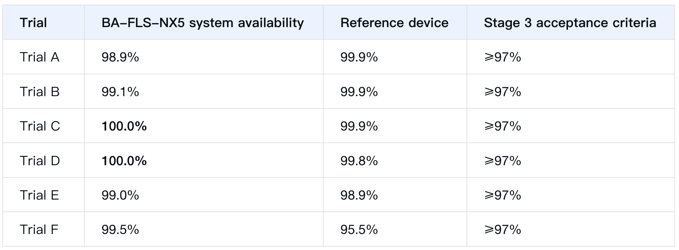
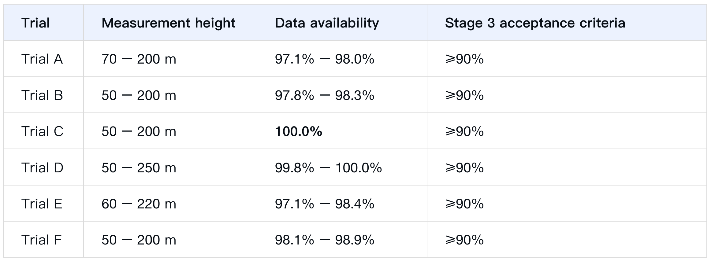
Second, data availability and reliability reach bankability. Across all six trials, the BA-FLS-NX5 achieved system availability of 98.9% – 100.0% (Stage 3 acceptance criteria: overall ≥ 97%) and data availability of 97.1% – 100.0% at all assessed heights (Stage 3 acceptance criteria: overall ≥ 90%).
Third, the uncertainty assessment is better founded. The report provides third-party-verified evidence on wind speed deviation, variation, availability, and environmental adaptability, giving developers and wind resource consultants traceable inputs for P50/P90 assessments and reducing the conservative assumptions that arise when system evidence is insufficient.
Fourth, front-end project verification is more efficient. Stage 3 has already established systematic type verification, offshore classification, and long-term operational evidence, so a project does not need to build a system maturity evidence chain from scratch; new projects can still carry out the necessary unit-level verification in line with site conditions and financing requirements.
For clients, choosing a Stage 3 supplier means the system has already undergone standardised, industry-recognised verification, and that its data quality, measurement performance and uncertainty levels rest on clearer, traceable technical grounds — reducing the cost of repeatedly verifying data reliability during project development, financing and due diligence.
3. First in Asia: Design Philosophy to Ensure Stage 3
The BA-FLS-NX5 with Molas B300M has achieved certification under OWA Roadmap v3.0 Stage 3, making it the first floating LiDAR system in Asia to reach this maturity stage. This is an inevitable outcome. It reflects engineering capability across the board, from system architecture and structural design to motion compensation algorithms and the verification framework.
System Architecture — Dual LiDAR with full-chain redundancy. The BA-FLS-NX5 is configured with dual LiDAR by default and is compatible with several LiDAR models, including the ZX 300M (continuous wave), WindCube v2.1 (pulsed wave), and Molas B300M (pulsed wave). Hardly any platforms are able to reach the Best Practice result with multiple LiDAR models. Power supply, storage and communications are all fully redundant, eliminating single points of failure — the architectural basis for its “system availability above 97%”.
Structural Design — Multi-compartment buoyancy plus dual-layer collision protection and redundant navigation. The compartments are independently sealed, so the buoy retains sufficient buoyancy even if all of them take on water. Dual AIS and dual navigation lights reduce collision risk, while a double-layer reinforced protection ring resists external impact. These design choices respond directly to the Stage 3 requirement for “reliability over the long term under real sea states”.
Correction Algorithm — Physics-based. The core technical foundation of this certification is Blue Aspirations' independently developed motion compensation software, BA-AMC-M-1.05. Derived directly from the Doppler measurement principle, it applies pure physical modeling without training data and operates across varied sea conditions independent of any manufacturer. This same capability underpins the key Stage 3 requirement that the sensitivity of accuracy to environmental variables be controllable and its uncertainty traceable.
4. Data Results
4.1 System Availability — Across Six Trials, Far Above the Acceptance Criteria
4.2 Data Availability — Across All Heights, Far Above the Acceptance Threshold
4.3 Regression Accuracy — Reported Both as Raw 10-min Data and as 0.5 m/s Binned Data
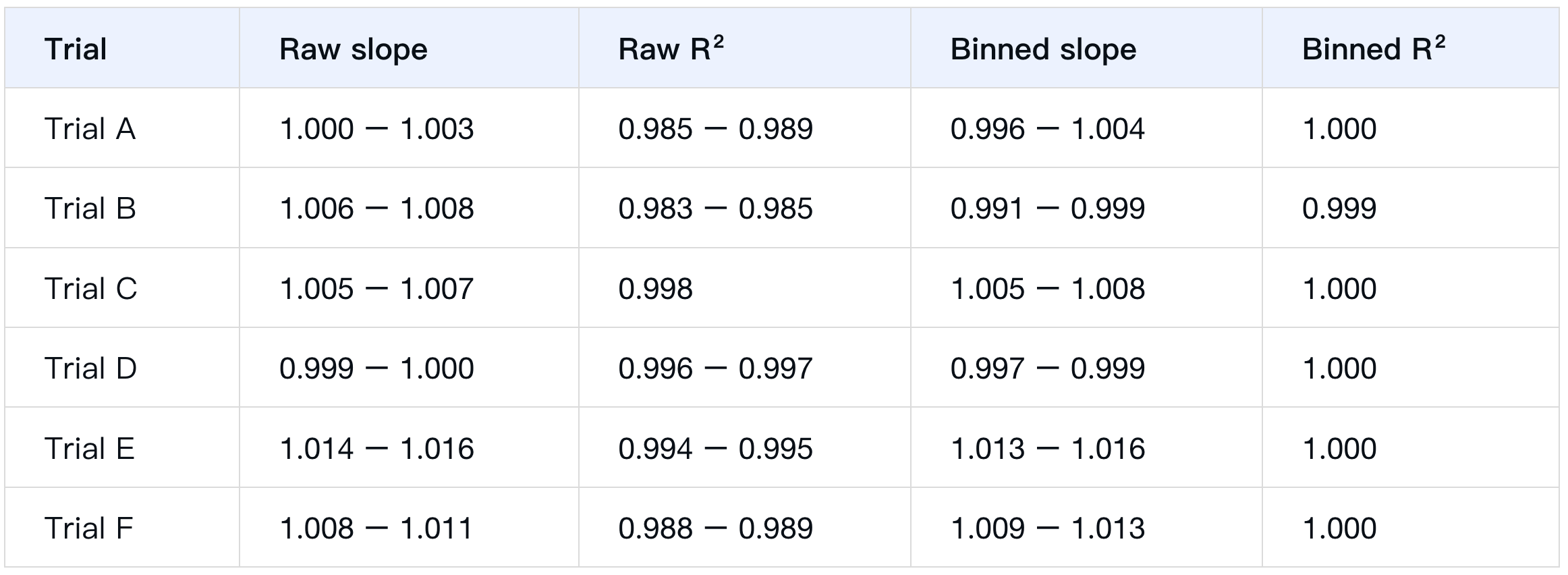
The Stage 3 acceptance criteria is a slope of 0.98 - 1.02 and R² > 0.98, and all trials met the criteria at all heights and across all wind speed bins. Wind direction accuracy likewise met the threshold (slope 0.97–1.03, R² > 0.97, deviation < 5°).
5. Verification in Complex Sea States: Storms, Collisions and Multiple Sea Areas
The Stage 3 evidence base does not cover only fair weather. The evidence chain has been cross-validated across both space and time, covering multiple sea areas and a range of complex conditions:
Storms: the BA-FLS-NX5 has been successfully deployed at offshore sites that experienced severe typhoons and storms. Its outstanding resilience derives from structural protection measures, redundant power and measurement systems, multiple communication channels and continuous remote monitoring. Field experience shows that the system maintains high system availability and excellent measurement performance even in severe weather conditions.
Collision prevention system: based on experience from real projects, occasional collisions at sea between a floating LiDAR system and vessels often cause serious damage. The BA-FLS-NX5 has therefore been comprehensively optimised in design beyond the standard AtoN (Aids to Navigation) requirement. A double-layer reinforced protection ring, verified by simulation to withstand collision with a vessel of several tens of tonnes without damage, protects the core components from major damage; multiple units of the same model are deployed on different masts, so damage to one mast does not affect system function; an AIS receiver monitors the surrounding waters in real time and triggers an active acoustic alarm when a vessel comes too close; and continuous monitoring of the unit’s motion triggers an alarm within 10 minutes of a collision, allowing timely manual intervention. These measures have been validated in real projects: field data show a lower probability of collision than with earlier designs and, more importantly, data transmission remains completely uninterrupted even when a collision occurs — in some cases no on-site maintenance was required afterwards.
Multi-Region Coverage: from the Yellow Sea in northern China, through the East China Sea in the centre, to the South China Sea in the south; eastwards to Japan, southwards to the Philippines and Thailand, and as far as the North Sea in Europe — the BA-FLS-NX5’s trials and commercial deployments now span the world’s most representative offshore wind development regions.
Differing water depths, wave and current conditions and wind resource characteristics — these “genuinely diverse marine environments” form a long-term, demanding proving ground for the BA-FLS-NX5.
6. Extended Capabilities: Turbulence Intensity Correction Algorithm Verified by an Independent Third Party
In addition to wind speed and wind direction measurements—which have been verified to have reached commercial maturity (Stage 3)—Blue Aspirations also offers a turbulence intensity correction algorithm built on its floating LiDAR wind measurement system.
Turbulence Intensity Correction Algorithm: When a floating LiDAR measures turbulence intensity, buoy motion causes the LiDAR beam's sampling in space to change, introduce bias into the turbulence measurement. Blue Aspirations' algorithm is based on physical principles and corrects both the bias induced by buoy motion and errors inherent in the LiDAR measurement principle, thereby improving the accuracy of turbulence measurements.
Independent Third-Party Verification: "The Carbon Trust Offshore Wind Accelerator roadmap for the commercial acceptance of floating LiDAR technology v3.0" introduces a "+" designation to specifically assess a floating LiDAR system's turbulence measurement capability. Building on acceptance of the wind speed, wind direction, and reliability requirements of Stage 2 or Stage 3, a system whose turbulence intensity measurement capability also passes the defined assessment can achieve "Stage 2+" or "Stage 3+." Previously, the BA-FLS-NX5—equipped with the ZX continuous-wave LiDAR and the WindCube pulsed LiDAR—received Stage 2+ reports from the international third party, for its turbulence correction algorithm, demonstrating the algorithm's effectiveness and reliability under real offshore conditions. Currently, the three different LiDAR models integrated into the BA-FLS-NX5 are also advancing toward Stage 3+ certification.
Scientific Rigor and Extensibility: Blue Aspirations' algorithm development follows a scientific methodology—grounded in physical principles and subjected to rigorous validation and iteration. At the same time, the algorithm exhibits strong extensibility, adapting to different buoy platforms, different LiDAR models, and different sea-area conditions.
7. Final Thoughts
The progression from Stage 2 to Stage 3 is attributable to Blue Aspirations' adherence to the no single point of failure principle — throughout this period we continuously optimized the system's power-supply capability, collision-prevention capability and, indeed, its overall safety and reliability, so as to steadily meet the challenges of complex and variable marine environments. Going forward, we will take the Stage 3 commercial certification as an opportunity and, in response to the more diversified and intelligent needs of marine measurement systems, continue to improve.